Coumloughra Horseshoe pics
We now come to what has got to be the best days walk of the holiday and the day during which I believe the best pictures were taken. The day had started very cloudy but as I climbed the hill the clouds revealed the scene in the first photo in the walk report. This was taken on top of the ridge leading to Skregmore looking past the opposite end of the horseshoe showing the spectacular temperature inversion with the clouds drifting out of the glen. The next picture in the walk report is a Brocken Spectre, a common atmospheric effect during temperature inversions. This one was not particularly clear but the shape enveloped in the halo was me, standing on a rock, taking the picture.
The picture below was taken from the same ridge as the two pictures above and shows Skregmore with Beenkeragh behind. At this point the clouds had re-entered the glen as they gradually lifted out of the valleys. The next picture shows the highest hill in Ireland, Carrauntoohil, surrounded by the ascending clouds.
 This picture was taken over an hour after the previous one during which time I had walked around the back of Beenkeragh onto Knockbrinnea, where this picture was taken. The clouds were now all around me as it rose past the mountain tops.
  The next picture shows the start of the narrow ridge linking Beenkeragh and Carrauntoohil. The guy I walked with for part of this walk can be seen making the crossing ahead of me. The clouds almost obliterate the left hand side of the ridge but the tip of Carrauntoohil can just be seen peaking through the clouds.
I took many pictures once on the top of Carrauntoohil including the third picture in the walk report that shows to good effect the large metal cross that adorns the summit. This picture was taken by descending the north face to the edge of the cliff and looking back at the summit. I was able to get a picture of the summit without any people in view or any sign of a footpath as these were all on the other side of the mountain. I'm quite proud of this picture, but of all the pictures I took on top of Carrauntoohil I think the one below is my favourite. It was taken from the footpath leading down to the top of the Devil's Ladder and clearly shows the six summits of the MacGillycuddy's Reeks with Lough Callee in Hags Glen below. I like this picture so much I have made it the wallpaper on the desktop of my computer. As you can see the clouds had now dispersed enabling me to take some of the best pictures of the holiday.
 The next picture was taken at the col between Carrauntoohil and the final mountain of the horseshoe, Caher. Lough Eagher, Coomloughra Lough and Lough Eighter can be seen in the glen with Brandon Mountain crowning the Dingle Peninsula in the distance. This picture has also graced the desktop of my computer.
A sea mist prevented any good pictures being taken while on Caher, but cleared as I neared the floor of the glen letting me take some more cracking pictures like the last picture from the walk report, which shows the whole horseshoe from Beenkeragh on the left through a hazy Carrauntoohil to Caher on the right. Lough Eighter lies in the foregound. I wish I could have put more pictures up from this walk, but I think this will have to be the limit. It has been really difficult trying to decide which pictures to include. I took almost 50 pictures during this walk and few were duds. It was certainly the highlight of the holiday for me.
The picture below was taken from the same ridge as the two pictures above and shows Skregmore with Beenkeragh behind.
At this point the clouds had re-entered the glen as they gradually lifted out of the valleys. The next picture shows the highest hill in Ireland, Carrauntoohil, surrounded by the ascending clouds.This picture was taken over an hour after the previous one during which time I had walked around the back of Beenkeragh onto Knockbrinnea, where this picture was taken. The clouds were now all around me as it rose past the mountain tops. 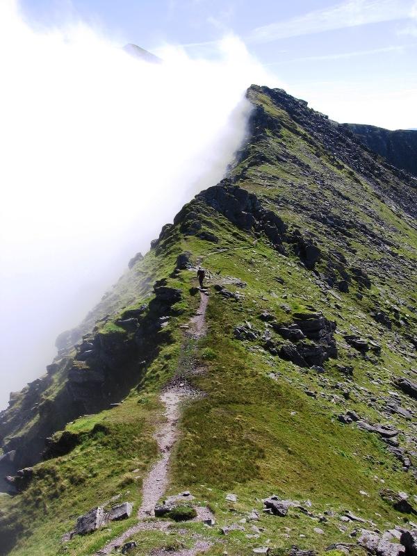 The next picture shows the start of the narrow ridge linking Beenkeragh and Carrauntoohil. The guy I walked with for part of this walk can be seen making the crossing ahead of me. The clouds almost obliterate the left hand side of the ridge but the tip of Carrauntoohil can just be seen peaking through the clouds.
I took many pictures once on the top of Carrauntoohil including the third picture in the walk report that shows to good effect the large metal cross that adorns the summit. This picture was taken by descending the north face to the edge of the cliff and looking back at the summit. I was able to get a picture of the summit without any people in view or any sign of a footpath as these were all on the other side of the mountain. I'm quite proud of this picture, but of all the pictures I took on top of Carrauntoohil I think the one below is my favourite. It was taken from the footpath leading down to the top of the Devil's Ladder and clearly shows the six summits of the MacGillycuddy's Reeks with Lough Callee in Hags Glen below.
I like this picture so much I have made it the wallpaper on the desktop of my computer. As you can see the clouds had now dispersed enabling me to take some of the best pictures of the holiday. The next picture was taken at the col between Carrauntoohil and the final mountain of the horseshoe, Caher. Lough Eagher, Coomloughra Lough and Lough Eighter can be seen in the glen with Brandon Mountain crowning the Dingle Peninsula in the distance. This picture has also graced the desktop of my computer.
A sea mist prevented any good pictures being taken while on Caher, but cleared as I neared the floor of the glen letting me take some more cracking pictures like the last picture from the walk report, which shows the whole horseshoe from Beenkeragh on the left through a hazy Carrauntoohil to Caher on the right. Lough Eighter lies in the foregound. I wish I could have put more pictures up from this walk, but I think this will have to be the limit. It has been really difficult trying to decide which pictures to include. I took almost 50 pictures during this walk and few were duds. It was certainly the highlight of the holiday for me.
posted by David Keates at 8:22 pm
0 comments
![]()
 The next picture was taken on the road part way up the valley on a bridge over the River Loe looking across the Black Lake at the dark cloud-topped Gap ahead.
 The wind was howling down the valley at this point, so much I had difficulty holding the camera steady. The last picture in the
 Auger Lake can be seen again now looking back down into the valley with clear blue skies beyond it. The only clouds in the area were over the mountains including over the Gap of Dunloe. The middle picture in the
  A poor start to the day with little opportunity for photo-taking had turned into a spectacular afternoon resulting in some, in my modest way, quite good pictures. But these pale in comparison with the pictures I took on the following days walk.
 The sun is shining through the clouds on top of Purple mountain into this picturesque valley. The first picture on the

 The clouds were now heavy on the southern side of the Reeks and would soon envelop all around. This next picture shows the narrow ridge from The Big Gun leading up to the highest point in the Reeks (east of Carrauntoohil), Cnoc na Péiste.
 Once on this ridge I was surrounded by cloud for the rest of the walk until I descended into Hags Glen. The third picture in the